Notice: Undefined index: primary_ip in /membri/k3csg/wxusalerts-varsize.php on line 1010

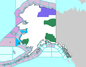
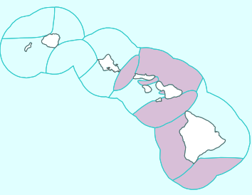
Clickable NWS National Advisory Maps

US Large Image Map
US Alaska Map US Hawaii Map
Hudson to Baltimore Canyon Southern Florida NE Gulf N of 25N E of 87W Gulf from 22N to 25N E of 87W including Straits of Florida NW Gulf including Stetson Bank N Central Gulf including Flower Garden Banks Marine Sanctuary W Central Gulf from 22N to 26N W of 94W Central Gulf from 22N to 26N between 87W and 94W Atlantic from 27N to 31N W of 77W Atlantic from 27N to 31N between 70W and 77W Atlantic from 27N to 31N between 65W and 70W Bahamas N of 22N including the Cay Sal Bank Atlantic from 22N to 27N E of Bahamas to 70W Tropical N Atlantic from 15N to 19N between 55W and 60W Caribbean N of 18N between 76W and 85W including the Cayman Basin Caribbean N of 18N between 76W and 85W including the Cayman Basin Caribbean approaches to the Windward Passage Atlantic S of 22N W of 70W including approaches to the Windward Passage Cape Fear to 31 N Hatteras Canyon to Cape Fear Baltimore Canyon to Hatteras Canyon Baltimore Canyon to the Hague Line South of New England Georges Bank Gulf of Maine Newport/Morehead City, NC Brownsville, TX Corpus Christi, TX Houston/Galveston, TX New Orleans, LA Lake Charles, LA Mobile, AL Tallahassee, FL Tampa, FL Miami, FL Key West, FL Florida Keys Miami, FL Melbourne, FL Jacksonville, FL Charleston, SC Wilmington, NC Baltimore/Washington, DC Wakefield, VA Philadelphia/Mt. Holly, PA/NJ New York, NY Boston, MA Gray/Portland, ME Intra Coastal Waters from Schoodic Point ME to Stonington ME Coastal Waters from Schoodic Point ME to Stonington ME out 25 NM Waters from Eastport ME to Stonington ME from 25 to 40 NM Waters from Eastport ME to Stonington ME from 25 to 40 NM Northeast Minnesota and Northern Wisconsin Northern Michigan Northern Michigan Northern Michigan East Central Wisconsin - Green Bay East Central Wisconsin - Green Bay Southern and Southeastern Wisconsin Northeastern Illinois and Northwestern Indiana - Chicago Northern Indiana and Northwestern Ohio Southwestern Michigan Northeast Michigan - Gaylord Northeast Michigan - Gaylord Northeast Michigan - Gaylord Southeastern Michigan - Detroit Southeastern Michigan - Detroit Southeastern Michigan - Detroit Northern Ohio Western New York - Buffalo Western New York - Buffalo Northern Michigan Point Conception To Guadalupe Island Point Arena to Point Conception Point St. George to Point Arena Cape Lookout to Point St. George Cape Flattery to Cape Lookout Los Angeles, CA San Diego, CA San Francisco Bay Area/Monterey, CA Eureka, CA Medford, OR Portland, OR Seattle, WA Los Angeles Area Los Angeles Area Los Angeles Area Los Angeles Area Los Angeles Area Los Angeles Area South Central California San Francisco Area Western Nevada North Central California Northwest California Coast Southwest Oregon and Northern California Northeast Oregon and Southeast Washington Northwest Oregon Northwest Washington Eastern Washington and Northern Idaho Southern Nevada, Southeastern California and Northwestern Arizona - Las Vegas Southwestern California - San Diego Central Arizona and California Deserts Southeast Arizona Northern Arizona Utah Northern and Northeastern Nevada Southwestern Idaho and Eastern Oregon Southeastern Idaho Western Montana and Central Idaho Central Montana - Great Falls Northeastern Montana Southeastern Montana Western Wyoming Southeastern Wyoming and Western Nebraska Northeastern Colorado Western Colorado and Eastern Utah Southeastern Colorado Northern and Central New Mexico Southern New Mexico and extreme Western Texas - El Paso Texas and Oklahoma Lubbock and South Plains Texas Western Texas and Southeastern New Mexico Western South Dakota and Northeastern Wyoming Northwestern Kansas and East Central Colorado - Goodland Central Nebraska - North Platte North Central Kansas and South Central Nebraska Southeastern South Dakota, Southwestern Minnesota, and Northwestern Iowa Northern and Northeastern South Dakota Western North Dakota Eastern Nebraska and Southwestern Iowa - Omaha Valley Northeastern Kansas Southeastern Kansas Southwestern Kansas - Dodge City Central Oklahoma Eastern Oklahoma and Northwestern Arkansas Dallas and Fort Worth Central Texas - San Angelo Austin and San Antonio Texas Corpus Christi, Victoria, and Laredo Texas Southern Texas Texas - Houston/Galveston Southeast Texas and Southwest Louisiana Northern Louisiana and Eastern Texas - Shreveport Arkansas Southwestern Missouri Northwestern Missouri Central Iowa Southern Minnesota Northeastern North Dakota and Northwestern Minnesota Northeast Minnesota and Northern Wisconsin Southwestern Wisconsin, Southeastern Minnesota, and Northeast Iowa Eastern Iowa and Northwestern Illinois - Quad Cities Eastern Missouri - West Central Illinois Western Tennessee, Eastern Arkansas and Northern Mississippi - Memphis Central Mississippi Southeastern Louisiana Middle Tennessee Northern Alabama Central Alabama Mobile - Pensacola West Central Florida East Central Florida Panhandle of Florida and Southwestern Georgia Northeast Florida and Southeast Georgia Northern and Central Georgia Low Country of South Carolina and Georgia Northeastern South Carolina and Southeastern North Carolina - Wilmington Central South Carolina and CSRA Western North Carolina and Northwest South Carolina Eastern Tennessee Eastern Kentucky Central Kentucky Southern Illinois and Indiana, Southeastern Missouri and Western Kentucky Central and East Central Illinois Central Indiana Northeastern Illinois and Northwestern Indiana - Chicago Southern and Southeastern Wisconsin East Central Wisconsin - Green Bay Northern Michigan Northeast Michigan - Gaylord Northeast Michigan - Gaylord Southeastern Michigan - Detroit Southwestern Michigan Northern Indiana and Northwestern Ohio Southwestern Ohio Northern Kentucky West Virginia Western Virginia, Southeast West Virginia, and Northwest North Carolina Central North Carolina - Raleigh Eastern North Carolina Eastern Virginia, Southern Maryland and Northeast North Carolina Washington D.C., Central Maryland, Northern Virginia, Eastern West Virginia Western Pennsylvania, East Central Ohio and Extreme Western Maryland Northern Ohio Central Pennsylvania New Jersey, Delaware, and Southeastern Pennsylvania New York City and Surrounding Areas South Central New York and Northeastern Pennsylvania Western New York - Buffalo Eastern New York and Western New England Areas Boston and Surrounding Areas Northern Vermont and New York Southern Maine and New Hampshire Northern Maine Juneau, AK Fairbanks, AK Anchorage, AK Western US Arctic Offshore Eastern US Arctic Offshore Bering Sea offshore 171 degrees West to 180 degrees and north of 56 degrees North Bering Sea offshore 171 degrees West to 180 degrees and south of 56 degrees North Pribilof Islands (St. Paul and St. George) Bering Sea offshore east of 171 degrees West Gulf of Alaska offshore north of 57 degrees North and west of 144 degrees West Gulf of Alaska offshore south of 57 degrees North north of 55 degrees North and west of 144 degrees West Gulf of Alaska north of 55 degrees North and east of 144 degrees West Juneau, AK Honolulu, HI Hawaiian Offshore Waters Hawaiian Offshore Waters


Notice: Undefined variable: oddLegend in /membri/k3csg/wxusalerts-varsize.php on line 866

Click on map to open a new tab zoomed to the area of interest where the local legend also decodes the colors and links to detailed local text alerts. The NWS map which opens is in turn clickable to then display VERY localized conditions and a 7 day forecast.
All Maps and Data Are Courtesy of NOAA/NWS. (Current NWS Alerts Color Code Chart)
Experimental Freeze Alert Status courtesy of MRCC Vegitation Impact Program (VIP).
Special thanks to JJ Krawczyk aka jaisu for the map resizing code.